Research Assistant
Contributed to early-stage planning for low-carbon district energy infrastructure in Cumberland, BC by translating technical concepts into interactive visualizations and decision-support materials for community engagement.
PhD Candidate in Public Administration · Participatory Planning Researcher · GIS Analyst
I am a PhD candidate in Public Administration at the University of Victoria whose research explores collaborative land-use planning, community engagement, and scenario-based geographic visualization.
Scenario-based visualization exploring how future energy systems can be communicated through interactive landscape visuals.
View project →
Explores the use of realistic landscape visualizations as tools for communicating sea-level rise impacts and supporting park management discussions in protected areas.
View project →
An interactive visualization tool presenting future food system scenarios for Revelstoke in 2100. Users can walk through a neighbourhood around a former railway site and explore community-developed scenarios focused on food supply, affordability, and governance.
View project →
Developed for UVic Libraries Digital Scholarship Commons, these workshop materials introduce researchers to QualCoder as an open-source tool for qualitative data analysis, including step-by-step guidance, workshop slides, and practical workflow support.
View materials →A practical guide developed for CSPC to help renters, low-income households, and other vulnerable community members prepare for and respond to extreme heat events.
View guide at CSPC →Completed with CSPC, this report synthesizes socioeconomic indicators related to housing, health, income, employment, and community well-being to support municipal planning and decision-making in Colwood.
View report →A reflective ArcGIS StoryMap exploring my relationship with land, place, and belonging through maps, images, and personal narrative.
View StoryMap →ACET, Victoria, BC
Contributed to early-stage planning for low-carbon district energy infrastructure in Cumberland, BC by translating technical concepts into interactive visualizations and decision-support materials for community engagement.
UVic Libraries DSC, Victoria, BC
Developed and delivered qualitative research software training, including NVivo, Taguette, and QualCoder, while supporting students and researchers with coding workflows, troubleshooting, and open-access training resources.
Community Social Planning Council, Victoria, BC
Conducted GIS-based spatial equity research on access to housing, transportation, and essential services, supporting policy recommendations and data-informed community engagement.
University of Royal Roads, Victoria, BC
Developed interactive visualizations of community-generated food system scenarios for Revelstoke, BC, supporting stakeholder workshops on climate justice, food systems planning, and JEDI-informed futures.
Community Social Planning Council, Victoria, BC
Co-developed a practical extreme heat preparedness guide and a household prosperity baseline report for the City of Colwood, translating research and socioeconomic indicators into public-facing and policy-relevant resources.
University of Victoria, Victoria, BC
Supported undergraduate instruction in GPS navigation, field data collection, GIS analysis, spatial modelling, mapping, and multicriteria analysis.
Government Technology Agency of Singapore
Managed GIS and IT projects supporting public service delivery, including a rapid public-facing parks footfall web map, a multi-million-dollar tree inventory platform, and technical documentation for system implementation.
National Institute of Education, Singapore
Contributed to an online resource portal for secondary school teachers to support the integration of GIS and geospatial technologies into classroom learning.
Esri, Singapore
Managed large-scale spatial databases, standardized GIS data governance processes, automated geospatial workflows, and delivered professional ArcGIS training across multiple technical topics.
University of Victoria · 2024–Present
Research focuses on collaborative land-use planning, participatory systems mapping, and scenario-based landscape visualization for community-informed decision-making.
Current research: Climate–Biodiversity–Health nexus, systems mapping, and landscape visualization in land-use planning.
Current research: Fort Saskatchewan projectUniversity of Victoria · 2020–2023
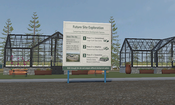
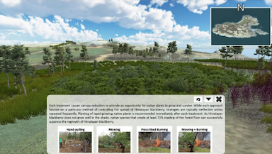
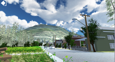
My research focused on the use of landscape visualization as a tool for stakeholder engagement in environmental planning. I developed a visualization tool for Mitlenatch Island, BC, to support discussions on invasive species management and to explore how visual methods can help bridge ecological knowledge, management practice, and community-informed decision-making.
The project involved engagement with BC Parks, First Nations communities, and other interested parties to understand different perspectives on landscape change, planning priorities, and management options. I also conducted qualitative analysis of stakeholder discussions to identify key themes, concerns, and recommendations for more informed and inclusive planning.
View Project →University of British Columbia · 2009–2013
Built a strong foundation in GIS, spatial analysis, quantitative methods, and environmental data interpretation, which continues to inform my applied work in scenario analysis, visualization, and planning decision-support.
Imagining Just and Sustainable Food Futures: Using Interactive Visualizations to Explore the Possible Land Uses and Food Systems Approaches in Revelstoke, Canada
Robert Newell, Colin Dring, and Elvia Willyono
Land, 2024
Geovisualization for Effective Management of Invasive Species: Bridging the Knowing-Doing Gap
Elvia Willyono, Christopher Bone and Robert Newell
Parks, 2024
Fire Hall Response Time Analysis in Seven Municipalities in Greater Vancouver Using GIS: How Population Growth Affects Service Areas
Yu Jia Guo, E. Conor B. McLellan & Elvia Willyono
Trail Six, 2013
Feel free to reach out, I'd love to connect!